岡部宿(Okabe inn town): it is fairly a big inn town
After going over the strenuous Utsunoya pass, you will get to Okabe inn town soon.

Okabe is fairly a long inn town. Let’s check it out!
For more details, check out the reference section.

The. I found an old map and compared. See the link below. The old map is
https://stroly.com/viewer/1631168167 (古地図で見る駿州の旅【岡部宿編】Posted by Sunshu Travel Japan Heritage Promotion Council Secretariat. Stroly.com)
The old map is 東海道分間絵図(Tokaido Bunken Ezu). And this map agrees with the road sign and Google map. There used to be Masugata square here.
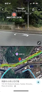 There is a small toro light.
 This is where AMZ’s map pointed out as Edo-side guard gate. It does make sense to have a gate right by the river though. But right begire crossing the river, there is 90-degree curve, which is a typical structure of defense in inn towns.
 Passing by O-hatago Kashibaya. It was a hatago inn(equivalent to business hotel today), and it turned to be a museum today.
 The honjin inn used to be here.
 This small bridge is where Ono no Komachi(825-900) looked at her own face reflected on the water and lamented because she was old. She was the symbol of beautiful woman.
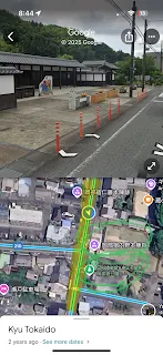
 This part preserves what Tokaido used to look like very well.
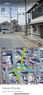
 Of course, this is an area where lots of locals live quietly. Please be respectful.
 Kosatsuba information board used to be here.
 Toiyaba cargo and postal terminal was where I circled.
 There is Toro light, and thus us where Kyoto-side mitsuke guard gate was.


Again, Okabe inn town is a hard one to get. It takes about 30 minutes by Shizutetsu Just Line bus from JR Fujieda station. The bus seems to come every 30 minutes.
The next stop is Fujieda inn town
References:
Ono no Komachi. Wikipedia.com. https://en.m.wikipedia.org/wiki/Ono_no_Komachi (Accessed in 6/10/2025)
Stroll map(of Tokaido). AMZ Environmental Design Research Office Ltd. http://shizuoka-tokaido.biz/en/map/index.html (Accessed in 6/4/2025)
Sunshu Travel by an Old Map “Okabe Inn Town”(The original title: 古地図で見る駿州の旅【岡部宿編】) Sunshu Travel Japan Heritage Council Promotion Secretariat. On Stroly.com. https://stroly.com/maps/1631168167/ (Accessed in 6/8/2025)


Comments
Post a Comment